Perimeter Hamilton.
THE JOURNEYWhat do you think of when you think of Hamilton?
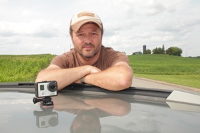
Perimeter Hamilton is a 3 hour, 200km journey around the city border. With a detailed map and a GoPro camera attached to the roof of the car, this unique documentary captures Hamilton in a way that has never been done before. Featuring the beauty of all the amalgamated communities, Perimeter Hamilton will change the way you look at the city. Take the journey. The three main things that ran through my head were "I can't believe this is still Hamilton," " I wonder if the people out here feel they are part of Hamilton," and lastly "I can't believe how beautiful this is." The finished documentary will be a 3hr 10m, unedited drive around the city perimeter. I don't expect people to sit for the entire journey but kudos if you do, and be sure to let me know! Take it in sections or look for the places you haven't been. If you are someone without access to transportation (and there are no busses out here, baby) sit back, and enjoy the ride. I took the journey twice before creating the final version of the movie. I needed to create a good map (I made a few wrong turns and some streets don’t have signs) and wanted to give myself some rules. Rule 1: Stay as close to the perimeter as possible using main roads Rule 2: Release the movie, unedited Rule 3: Start and end on the bridges. Rule 4: Don’t use GPS (I’m a paper map kinda guy) I did map out, and drive, all the streets that are closer to the perimeter in subdivisions off the North Service road and off Highway5 / Dundas St, but it was too dizzying and you really end up driving in and out on the same streets. On the map, it looks like you can get from Haldibrook road from Westbrook road but you can’t unless you have an ATV. I exited at Hall Road. With a few turns, you’ll get to Haldibrook. I do offer my directions on this page but If you are planning this trip, you should really make yourself a map and have a good sense of direction. From one trip to another, street signs disappeared, roads were closed and detours appeared. Luckily, on my third trip, it was the route I had planned with no troubles. I took spec reporter Jeff Mahoney on m fourth trip and we encountered a closed bridge and a few missing signs. You never know! I learned a thing or two from Wray Anderson at IC Supercomputers. I was asking him about backroads to his store and after he explained them he said “Native wisdom, look for a sign” |
Perimeter Hamilton from nathan fleet on Vimeo. To view specific sections go to the following times:
Hamilton Start 00:00 Stoney Creek 10:40 Glanbrook 32:30 Ancaster 58:30 Flamborough 1:25:20 Dundas 2:47:30 Hamilton 2:51:00 To get direct links, look in the description at go to vimeo.com/nathanfleet/perimeterhamilton THE DIRECTIONS
City maps that helped me create the route
City of Hamilton map Full City General Interest Map large file - 5 MB) City of Hamilton 11x17 B&W small scale map of the entire City (1 MB) THE PRESS
Hamilton Spectator (18/08/14) - Jeff Mahoney Read CH Morning Live (28 / 08 / 14) Watch Hamilton News (29 / 08 /14) Read Scott Thompson Show 900 CHML (22 / 08 / 14) THE CAMERAGoPro White edition
720p Ultra Wide (You can’t get Ultra Wide in 1080p on the White edition) 30fps 64GB micro SD card Mounted to the car using the adhesive mount with some duct tape for insurance :) USB cable to a power adapter to an extension cable into the drivers side window into the lighter adapter. I am not a cinematographer and am very much a “grab the camera an go” kind of person. I did do several tests regarding the placement of the camera. Attaching it to the roof really gave it a nice glide. | ||||||


